
When you feel stuck or caught between a rock and a hard
place, just look at the sky. Clouds remind us that everything changes. Or better
yet, scale this beautiful mountain named after the clouds and mist that
mystically surround it.

A mini-Middle Earth of Itogon, Benguet, Mt. Ulap Eco-Trail may be one of the best day hikes for those looking for adventure not that far from Manila. Rising 1,846 MASL, the trail is not that easy but it offers a wonderful view of pine trees, grassland ridges, rolling hills, rock formations, burial caves, and clouds that take different shapes and forms by the minute.
And it’s okay to hike solo. Even without any mountaineering gears. I left Manila on a weekend at 2:30 am. Arrived in Baguio by 8 am. Took a taxi going to Lakandula. Had a quick breakfast at McDo. Ordered take-out lunch from Jollibee. Took a jeepney bound for Samuyao and was dropped at Ampucao Elementary School. Registered at the barangay hall. Paid P500 for the registration and tour guide. And by 9:45, I’m on my way to see Ampucao’s famed and newest attraction, along with my young tour guide Clemens.
The Mt. Ulap Eco Trail is actually composed of six stages, which can be traversed in 5 to 8 hours, depending on one’s pace.
Stage 1 - Tomtombek. We started the climb from Sitio Tomtombek. There’s a kind warning that says “Keep Ampucao beautiful” or in short don’t dare vandalize. Simula pa lang, ascent agad. Kaya muntik na ako mapaatras initial stage pa lang hehe. Even if it was scorching hot, there are a lot of pine trees along the way, giving shade and oxygen, which kept us going. I was also surprised to find a wooden gate on the trail. Clemens said that it was built to keep the cows from escaping or wandering.


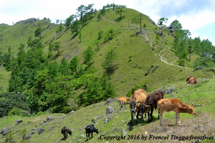
Stage 2 - Ambanao Paoay. I began to really appreciate the trail, the moment I reached the first peak - Ambanao Paoay. Cairns dot the summit of this hill. And herd of cows graze on this area.
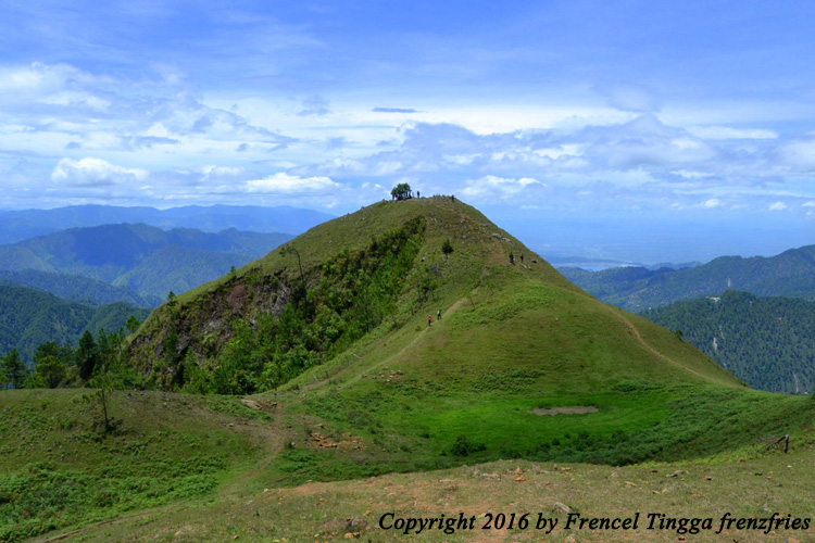


Stage 3 – Gungal Rock. The famous landmark of the trail is the Gungal Rock, large rock formations, where hikers queue just to take a photo-op – a solid evidence to show that they’ve really conquered the mountain. Another surprise came when I bumped into Mark and his friends who were also there on a dayhike.


Stage 4 – Mt. Ulap Summit. With its verdant rolling hills with a larger herd of cows, my most favorite station is the summit. When I saw the camping site, gusto ko magpa-iwan. Kung meron lang sana nagpap-rent ng tent within the vicinity, I wouldn’t think twice spending the night.


Stage 5 - Pong-Ol Burial Caves. The last attraction of the trail is the burial caves, which as of the moment are closed to the public. But Clemens still took me to two of the sites. Taking pictures of the skulls and the remains are strictly prohibited maybe to prevent “mummy theft incidence” that happened before (kaya dun sa mga palihim na nag-picture habang nakalingat ang guide, hindi na raw kayo makakaapak ng Ampucao hehe).


Stage 6 – Sta. Fe. Had I known of the steep descent going to Sitio Sta. Fe, bumalik na lang sana ako sa Ampucao. This part of the trail is the most difficult. Na-stress legs ko pababa. We passed by some locals who live in the area, a charming wooden house, and hanging bridges, before finally reaching the highway by 6 pm.


We finished the traverse in eight hours. I took a shower in
one of the houses. Rode a jeepney back to Baguio. Tambay ng tatlong oras sa
Victory. And four hours later, already back in Manila. I was actually hesitant
at first to try this challenge alone but I’m glad I did. Mountain climbing will
always be my first love.
At kahit hindi ako masyadong ready, naniniwala ako sa
sinabi ni Kat Ri na “You’re never going to be 100% ready and it’s never going
to be just the right time, but that’s the point. It means that every moment is
also the right moment. If you want it, you just have to do it.”
No comments:
Post a Comment