
We always come back to our first love.
Though this does not apply to
every person or circumstance, it works just fine for me. For despite all the skinned
knees and heartbreaks, I never get tired returning to my first love – mountain
climbing.

Exactly three years ago, I serendipitously read about Helen Aguila-Flores’ inspiring and exciting mountain climbing adventure to the not-so-then-famous Mt. Pigingan (kahit si Pinoy Mountaineer during that time di pa ito na-discover). Helen is a lawyer, a passionate nagbabalik-loob na mountaineer and surprisingly already a lola. Her online screenname is Lola Bundokera. And even though she’s nearing her senior year, this did not deter her to conquer this beautiful mountain in the mining town of Itogon, Benguet. I promised one day, that I would also set foot in Pigingan and have a daring escapade just like hers.

With an elevation of 1328 MASL and total hiking distance of 24 kms. (including backtrail), Pigingan is considered a “major hike” with 5/9 difficulty – katamtaman ang hirap. It is geographically situated near the tri-borders of Benguet, Pangasinan and Nueva Vizcaya, making its general weather hot during the day and cold during night and early morning. Its prominent features are scenic view of pine forest, Agno River and Cordillera mountains, rock scrambling, and a slanted knife-edge summit. The mountain got its name from the local dialect meaning “slanted”, which is actually the shape of its summit.

Matagal din naka-bookmark ang Pigingan sa akin. And despite our perennial busy sched in the office, I was determined to push through with it. I asked Mia and Jen na kahit tatlo lang kami, at mamulubi sa pagrenta ng sasakyan hanggang jump-off point, ituloy na namin. From the original three, we were able to recruit four more (Jeff, Christian, Pat, and Jovian); in the end, our group expanded to seven.
Since it would be a DIY climb, we made sure na everybody has their own task/assignment – securing bus tickets, coordinating with the local tourism, finding van driver, photocopying of our IDs, collecting money, to bringing food. By experience, mas may appreciation ang bawat members at maliit ang attrition rate kung kasama sila sa preparation at equally naghihirap. Mia was assigned TL, Jovian as ATL (kahit hindi nya alam ang mga tasks nya), and Pat as treasurer. Jeff was assigned to bring cook set while Jen was pressured to cook her usual adobo na she claimed mas masarap pa sa Angrydobo ni Juday.
The challenging part in the planning stage was actually finding the correct contact information of the Pigingan coordinator in Dalupirip – all the numbers we found online and in blogs are not working anymore. Sabi namin baka mahirap lang talaga ang signal sa bundok. To be sure, we asked Christian to message almost everybody that has been to Pigingan in Facebook and IG, and eventually, a good soul pointed us to Ate Kim, the new coordinator of Pigingan. Wala na si Ate Lany, ang dating coordinator, sumama na kay Kuya Bong :p
To make our hiking more convenient, we asked Ate Kim to find us a van that would transport us from Baguio to the jump-off point, tents for overnight camping, and prepare cooked food na babaunin na lang namin pag-akyat.
On the day of our climb, we left Manila 10:30 pm on a Friday night. We arrived in Baguio at 4:30 am the next day. Before proceeding, bumili muna ako ng bus tickets namin pabalik sa Manila, pumila sa courtesy lane ng Victory, inabot ng 10 minutes at sinumpa na ako ng lahat ng mga seniors na nakapila (sorry hehe). Our chartered van driver, Kuya Robert was already waiting for us at the terminal, pagbaba namin from ticketing office. We left by 5 am and it took us about an hour to reach the registration area. Ang daming kwento ni Kuya during the entire trip about his hometown, particularly the recent landslide (because of Bagyong Ompong and excessive mining) that claimed almost hundred lives in Itogon. He was telling me to feel every bump na nadadaanan namin, dahil slowly lumulubog na ang lupa as a result of mining. I could read between his lines, na if you abuse and get too much from mother nature, you will really pay dearly. Since I was seated beside him, I fought to stay awake kahit na nahuhulog na ang ulo ko sa sobrang antok hehe. Lahat borlogs na sa likod.

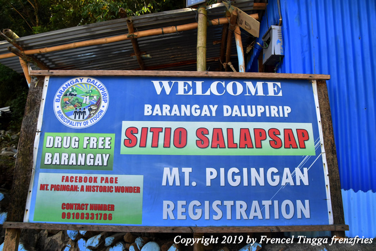
When we arrived at the registration area in Dalupirip, Sitio Salapsap, we were warmly welcomed by Ate Kim. After registering and having our breakfast, we were introduced to our 20-year-old guide Vince, who briefed us about the climb and what to expect. He told us that it would take us about four to five hours to get to the summit. But given our normal pace (dahil hindi naman kami hard-core mountaineers), expected many stops and our endless piktyuran and selfies along the way, we usually allot extra two hours. After the briefing, we travelled again by van for almost an hour to the jump-off point. Medyo makipot, maraming bangin and one way na rin ang final part ng daan so extra-challenge pag may makasalubong na sasakyan. We also passed by a road gate to keep away cattle from wondering into private properties or damaging crops. Refreshing sights of rice terraces, hamlets, and the snaking Agno River greeted us.


We briefly stopped by the river to see the locals panning for gold. Itogon is one of the biggest mining communities in Cordillera. Second to agriculture, mining is a major industry in Benguet and Itogon largely contributes to the province’s copper, gold and silver production. Small-scale miners along river banks is a common sight.

Pagdating sa jump-off point, doon na rin namin dinaanan ang aming porter na si Miro. After we bid adieu to Kuya Ricardo, we found out from our guide na he is the principal of the elementary school in the local community. We were all surprised.

The first part of the trail is relatively easy, starting from the hanging bridge, and continuing to an established dirt road (yung simula runs parallel to Agno River) that gradually rises until the intersection.


This intersection is also the halfway point of the trail. There are several natural spring water sources along the way and most parts are shaded, so medyo hindi nakakapagod. At the junction, there are three other paths that lead to Lawiguen, Oling Van-tic and Ti-vang. The area is also where the last sari-sari store could be found. We rested for a bit, bought delicious ice candies and siomai for snack, and afterwards had our lunch in this area. Tip: Sa mga may budget at gusto ng mabilis, at nagtitipid ng lakas at oras, may habal-habal that could be rented one way from the jump-off point to intersection (and vice versa) for P500. Pwede rin kabayo.


The real foot trail and serious ascent begins at this stage. Most part of the trail are open spaces so medyo draining na ang paglalakad under the scorching heat of the sun. Minsan napapaisip ako kung saan kumukuha si Mia ng lakas at nakakabirit pa ng kanta habang naglalakad, while ako halos nagdedeliryo na sa pagod. But dito na ring part unti-unting nare-reveal ang beauty ng Pigingan from the rolling hills, pine forests, and views of the Mt. Ugo and nearby mountains. Nakakapawi ng pagod. Remarkable are some of the dead, bare pine trees that were probably struck by lightning. They look like wondrous works of art and nature.


After six hours of trekking, we arrived at the camping site. Si Christian na very first time to climb, ang siya pa nauna sa aming lahat. The site is enclosed with log fence and barbwires mainly to keep out cows whose favorite grazing spot is within the vicinity. Cows are kinda friendly, some nagpapa-pet. We set-up our tents, rested for a while, and finally decided to continue to summit.


The final trail to the summit is a little bit difficult because it is mostly assault, but still very manageable. We passed by another pine forest.


It took us almost an hour to reach the highest point with the Pigingan marker. It was glorious to finally reach our destination after an arduous trek. Everybody was happy except Jovian because na deadbat ang GoPro nya. I exactly know the feeling, nag-aapela siya na bumalik kami the next day for sunrise but we outvoted him hehe. The 360 degree view on the summit ridge was exhilarating, breathtaking. It was almost sundown and fog started to roll, embracing the mountain, adding more charm and mystery.


There was no clearing for sunset. But we didn’t mind. We were still fully satisfied with the cool weather (hindi sya nakamamatay gaya ng sa Pulag pagsapit ng gabi), the captivating scenery, and the fun company. I guess we were lucky na two groups lang kami na nag-camp for the night, so solong-solo namin ang summit. Moreover, hindi rin masyadong commercialized ang Pigingan unlike its neighboring Mt. Ulap that attracts more than a hundred hikers on a weekend.
Dusk, the next day may not be that exceptional but still stunning, soothing.


We had less
than an hour to savour our last moments in Pigingan, before we descend. I remember Lola Bundokera’s words “I'd be
climbing, and trekking for the rest of my life, until my legs could walk no
more.” I wish I could also live to that pledge, and constantly be reminded that,
really “time is all we have.” I don’t want to wake up one day and find, I have
less than what I think to pursue the adventures that make my soul truly alive.
From Manila, take Baguio-bound bus. Though
commuting is possible from Baguio to Dalupirip, Itogon (take note though that
there are only limited PUJs), it is recommended to charter a jeepney or van (Sir
Ricardo-0921-2790232) from Baguio to the registration area and jump-off point. Pigingan
coordinator (Ate Kim-0910-8331786) could arrange for transportation, tent, and food.
For a group of seven (and up) and for overnight hike, prepare about P2,500 to
cover everything – from guide and porter fees, registration fee, tent rental,
transportation from Manila to jump-off point (and vice versa), and food. Shower
and toilet are available in the registration area. There is a nearby water
source and toilet in the camping site. Dayhike is possible even for beginners
but start very early, remember taga-patag kayo at hindi taga-bundok, iba ang
dimension nila pagdating sa layo at oras.