
Mt. Natib is a
botanist’s haven. I found so many exotic and fascinating plants the first time
I scaled this mountain.

Located in Orani, Bataan, Mt. Natib is a dormant volcano and caldera complex. It has an elevation of 1,253 MASL. The mountain and its adjacent surroundings are a protected area first declared as the Bataan National Park in 1945.

I tagged along with Mia and Jeff for this day hike. Straight from the office, we left Manila via bus past midnight and arrived at the junction in Orani around 4 am. We hired a tricycle that took us to the military headquarters in Tala (where we got our go-signal to climb) and finally the jump-off point.
Since we were very early for our meeting time and our hired guide was still probably sleeping (and dreaming), we decided to have an early breakfast in a nearby 24/7 restaurant that serves Batangas lomi and sisig. The place is where the mountaineers usually dine before and after the climb.


After our fulfilling meal, we proceeded to the barangay outpost where we registered; took a nap until our guide arrived. A little past 5 am, we commenced our hike.
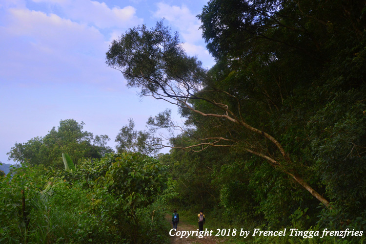
First part of the trail is the wide road (almost paved), gradually ascending and leading to the viewpoint. If there is actually a habal-habal for hire going up to the viewpoint, I would avail it to save my energy and time.

The viewpoint somehow reminds me of Picnic Grove in Tagaytay, only simpler, with very few or no people at all, and no entrance fee. Our guide said that it is often visited by visitors on a day tour.


The second part of the trail starts from the viewpoint to Pinagbutasan, where kubo huts and temporary shelter for mountaineers are waiting. The place also has a potable water source.


After a brief rest in Pinagbutasan, we continued on our journey, passed the fork - the upward trail leading to the summit, the other one to Pasukulan Falls.
Along the way we found different and interesting flora. Our guide even searched for rafflesia. It was our first time to see the giant flower and we were so excited to finally see one.


It gets steeper for the last and remaining part of the trail, with some parts very rocky and slippery. And one needed good rappelling skills to move up. Actually the rappelling part is the most exciting and one of the highlights of the trek.


We reached the summit past noon. The peak is marked with a DENR signpost, and features a small flat grassland. On a clear day, one could see the West Philippine Sea, most of Bataan Province, and the mountains of Mariveles, Samat, Cinco Picos, Balingkilat and Arayat. The view is breath-taking and wonderful, especially when the fog and clouds dance over or envelope the mountain!


After resting, taking our lunch and a hundred photo-ops, we started to descend in the same steep trail where we came from.
We would have loved to go to the falls; debated for a while, but unfortunately there was no more time, and we were not equipped to stay overnight. Also, I was victimized by a poisonous plant that I touched; it pricked me from the inside.

No one is ever safe in
this world.
From Manila, take Balanga-bound bus (bus terminals in Pasay, Cubao or Avenida)
and get off in Orani crossing. Take a tricycle to the jump-off point in Brgy.
Tala. Guides (Tel. Nos.: 0907-5681785; (047) 237-3550) are available in the barangay
outpost.
No comments:
Post a Comment