Say something, I'm giving up on you. I'm sorry that I couldn't get to
you.
Maraming yan ang theme song nung mag-weekend hike kami sa Tapulao. Pero kami hindi yey. Patibayan ang laban when scaling this mountain. Quite honestly, it requires a lot of patience, determination and endurance to finish the 18-km. trail to summit, the longest I’ve trekked so far. Kahit ako nagulat at nalumpo ng slight sa kakalakad ng 36 kms. just to complete the Tapulao experience.
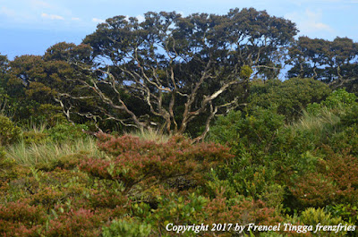
With an elevation of 2,037 m., Mt. Tapulao is the tallest mountain in the Zambales mountain range. It was once a site of a large-scale chromite mining operations but due to its disastrous effect to the environment, the danger it brought that almost led to the summit caving in, and protest from environmentalists and the people, the mine was forced to close. Tapulao is actually a local Zambal dialect meaning pine trees, and true enough the mountain’s killer view is the Sumatran pine trees near the summit.
We were supposed to dayhike Tapulao with my colleagues Jeff and Mia. Our initial plan was to start the trek very early morning, reach the summit by 2 pm and be back at the jump-off around night time. But that’s not what happened.
We left Manila around 10 pm, Friday night and arrived 4 am the next day in Iba. We rented a tricycle to take us to Sitio Dampay in Brgy. Dampay-Salaza, Palauig. After registering at the barangay hall and hiring a guide, we started the climb at 6 am.
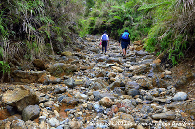
The trail is gradually ascending. But it’s 80% rocky road all the way to the summit. Andaming bato of all sizes from small to big and big-big. Nung nagsabog ata ang kalangitan ng bato, nasalo lahat ng trail. That’s why very important to have sturdy, soft, and comfortable shoes.
Occasional backward glance affords climbers with the view of Palauig and neighboring towns, Masinloc Power Plant and the West Philippine Sea.
A wide open field appears at Km. 4.
Potable water source is available at Km 6, 10, and 16. The spring water is also enjoyed by the households of the barangay for free.
Interesting flora and fauna could be found along the way – notable are the wild red berries, pitcher plant, and fiddlehead fern.
We had lunch stop-over in an open kubo at Km. 10.
The best views begin after Km. 11 because this is where tapulaos start to flourish. Nakakapawi ng pagod.
Fog starts to envelope the mountain accompanied with sporadic rain shower.
When we reached the first campsite around 5 pm, rain started to pour heavily. That’s when we decided that we will camp at the bunker house and stay the night kahit di kami prepared for an overnight stay with no food for dinner and breakfast, no jacket or sweater. Di na rin ata namin kaya bumaba sa sobrang pagod at sa lamig.
The bunker house used to be the sleeping quarters of the miners. It is now dilapidated and serves as a shelter for campers. Buti na lang may isang bed na medyo maayos pa, doon kami nagsiksikan na parang mga basang sisiw. We also made bonfire inside the house panlaban sa lamig. And even though we weren’t able to sleep properly because of the extreme cold (and the smoke coming from the bonfire), we managed to survive.
We were rewarded with a bright, sunny weather the following morning. It feels like we were transported to Cordillera because of the cool weather and the amazing view of pine trees and mountain ranges.
We also saw piles of uncollected mined deposits of chromite, remnants of the abandoned mining activity. This mineral is used in making stainless and tool steels. C-Square Mining used to dominate in this area until their final year of operation in 2008 when the LGU declared Mt. Tapualo as a protected area for eco-tourism. The mountain is not only rich in chromite but also silver, nickel, gold and copper ores.
We resumed our trek and entered the mossy forest. Ingat may mga tusong limatik sa forest.
It took us an hour before reaching the summit. Hallelujah! 14 hours to the highest peak and still standing! The two landmarks of the summit are the Km. 18 marker and the century-old world tree, which I guess is an Almaciga bonsai tree. Sorry inakyat namin huhu. Magaan lang naman kami. Pero wag nyo na kami tularan.
Pagbaba namin, tsaka na
namin nadaanan ang mga casualties – yung mga naabutan rin ng ulan yesterday at
binaha sa campsite nila na nagpaiwan na lang sa Km 10, yung mga nakontento na
lang sa Km 12, and those who were not able to finish until the summit. But they
weren’t failure, just unfinished success. I think they only need more motivation
or someone who could inspire them to finish the long journey, someone they
could tell “Because of you I didn't give up.”
From Manila, take Iba-bound bus (Victory Liner bus stations in Cubao or
Monumento). Better take a night trip (8 pm onwards) to arrive in Iba early
morning the next day. From Iba, rent a tricycle going to Sitio
Dampay in Brgy. Dampay-Salaza, Palauig (P450 one way good for 3-4 pax). Register
at Brgy. Hall and secure a guide (P1,000). Trekking time to summit takes 6
hours to 14 hours or more depending on your pace. It could be done in a dayhike
but better finish it in two days, kung mahal nyo ang mga paa nyo. Just bring
jacket as temperature drops by night time. Water source is not a problem.


2 comments:
Hello, I log on to your new stuff daily. Your humoristic style is witty, keep it up!
Ithink this is one of the most important info for me.
And i am glad reading your article. But want
to remark on few general things, The website style is perfect,
the articles is reall nice : D. Good job, cheers
Post a Comment